San José · Hatillo & the south
Cafés in Hatillo & the south
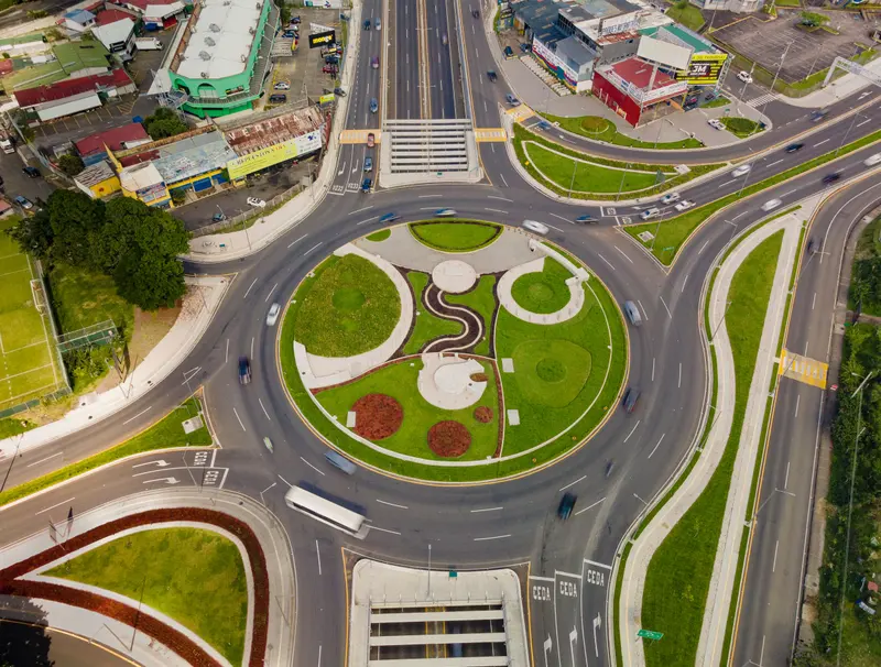
Coffee in Hatillo's satellite city, San Sebastián by Parque de la Paz and San Francisco de Dos Ríos near Parque Okayama.
Photo: Luis Alberto Arias, Pexels License
South of the center, three dense residential districts sit between two rivers, the María Aguilar and the Tiribí: Hatillo, San Sebastián and San Francisco de Dos Ríos.123 Hatillo takes its name from a hato (cattle herd) that belonged to the lay brotherhood of San José's hermitage and grazed the flat land between the rivers in the first half of the 18th century.1
There is no single café street here. Café Flamingo and Vibetos Cafetería Boutique are in Hatillo, El Rey is on Calle 12 in San Sebastián and Cafe Amarettos is on Route 211 in San Francisco de Dos Ríos. Closer to the center, Ciao Caffè on Calle 17, Cafecito Especias on Route 209 and The Coffee Square form a small group.
Local tip: At Ciao Caffè on Calle 17, ask for the especiales del día (daily specials) before you order from the menu; the kitchen runs from breakfast through lunch.8
At a glance
9Cafés listed
1With opening hours
09:00Earliest opening
18:00Latest closing
- Opens earliest: Ciao Caffè, from 09:00 (Mon–Fri 09:00–18:00).
Cafe Amarettos
Café Flamingo
Cafecito Especias
El Rey
Café & Espantos
Café Arábica Costa Rica
The Coffee Square
Vibetos Cafetería Boutique
Nothing matches those filters here. See all cafés in San José.
A prize-winning farm and a satellite city
Coffee came first. Before 1893 the brothers Francisco and Augusto Gallardo Prieto owned Finca El Hatillo, along almost two kilometers of the Tiribí, and its coffee was chosen to represent Costa Rica at the 1893 World's Columbian Exposition in Chicago, where it won a quality prize; it was exported only to England.1
In the mid-20th century the housing institute INVU built the Ciudad Satélite de Hatillo, and on April 29, 1956, President José Figueres Ferrer attended the handover of keys to the first residents of Unidad Vecinal 1.1 A University of Costa Rica study calls the Hatillos the country's first government-planned satellite city, and of the eight, Hatillo 8 gives the largest share of its streets to pedestrian lanes and the smallest to roads.4
Hatillo today
In 2011 Hatillo had 50,511 residents at 11,829 per square kilometer, the highest density in the canton, yet it also has one of the largest shares of green and recreational space per person.5 In 1983 its residents led national protests against a rise in electricity rates.1 Commerce arrived in the early 1990s with the Circunvalación ring road and the Plaza América and La Verbena shopping centers.1
Café Flamingo is in Bambú Eco Plaza, 300 m east of the Rancho Guanacaste roundabout, and Vibetos Cafetería Boutique is close by.
San Sebastián and Parque de la Paz
In the mid-19th century San Sebastián was known as La Isla (the island) because it lay between the María Aguilar and the Tiribí, and it was split into two sectors, Paso Ancho and San Sebastián; its first school opened in 1886.2 Like Hatillo, it filled with high-density social housing in the 1950s and 1960s, and it also holds the Seminario Mayor.6
Parque de la Paz, built in the late 1980s, covers more than 333,000 m² and gives the district the best green-space figures in the canton.6 In 1998 San Sebastián got the country's first hypermarket, Hipermás, later turned into a Walmart.2 El Rey is on Calle 12.
San Francisco de Dos Ríos and Parque Okayama
San Francisco de Dos Ríos is named for Saint Francis of Assisi and for the Tiribí and María Aguilar rivers on its southern and northern edges.3 Early in the 20th century fewer than 700 people lived here, growing coffee, vegetables and grain, and they went to church in Zapote: the district's own main church was only built in 1985.7 From the mid-1950s it grew fast, mostly with middle-class neighborhoods.7
Parque Okayama was built together with the Japanese city of that name, San Francisco's sister city, and has a duck pond, waterfalls, fountains and a stone garden.3 Cafe Amarettos is on Route 211, and Ciao Caffè, on Calle 17, serves breakfasts, salads, lunches and an apple tart with its own house coffee.8
Sources
- Hatillo (San José), Wikipedia (Spanish), accessed November 2026
- San Sebastián (San José), Wikipedia (Spanish), accessed November 2026
- San Francisco de Dos Ríos, Wikipedia (Spanish), accessed November 2026
- La estructura urbana: Análisis de la producción del espacio en Hatillo 8 (1973-1984), Universidad de Costa Rica, Escuela de Arquitectura (David Fernando Araya Díaz), 2016, accessed November 2026
- Distrito Hatillo, Municipalidad de San José (archived 2020), accessed November 2026
- Distrito San Sebastián, Municipalidad de San José (archived 2020), accessed November 2026
- Distrito San Francisco de Dos Ríos, Municipalidad de San José (archived 2020), accessed November 2026
- Ciao caffè, Ciao Caffè, accessed November 2026
FAQ
Hatillo & the south cafés: questions
Why is Hatillo in San José, Costa Rica called Hatillo?
The name comes from a hato, a cattle herd that belonged to the brotherhood of San José's hermitage and grazed the flats between the María Aguilar and Tiribí rivers in the early 18th century. In the 1950s the INVU built the Ciudad Satélite de Hatillo there.
Which cafés are in Hatillo and the south of San José, Costa Rica?
Café Flamingo and Vibetos Cafetería Boutique are in Hatillo, El Rey is on Calle 12 in San Sebastián and Cafe Amarettos is on Route 211 in San Francisco de Dos Ríos. Ciao Caffè, Cafecito Especias and The Coffee Square sit closer to the center.
What is Parque de la Paz in the south of San José, Costa Rica?
Parque de la Paz is a park in the San Sebastián district, built in the late 1980s, that covers more than 333,000 square meters. It gives San Sebastián the best green-space figures in the canton of San José.
For café owners
Own a café in Hatillo & the south?
Free listings are free for good. A featured page gives you photos, a menu and your own URL, in your café's own design, for less than a coffee a day.